DGPS Navigator JRC JLR-7700MKII
- Large LCD Display
- More Accurate DGPS Positioning. Differential GPS position data is automatically received in DGPS service areas, and own ship’s position fixes are displayed with very high accuracy.
- Up to 499 waypoints can be stored in the internal memory with their place names in 8 alphanumeric characters.
- Two data ports are provided: one is an RS-422 port, and the format is selectable from NMEA0180, NMEA0183 (version 1.5 or 2.1) and a JRC.
- Navigational calculations are made in the Great Circle or Rhumb Line mode.
- The GPS position fixes can be converted into Loran C or A time difference values and displayed on the LCD screen.
- A log pulse or external buzzer alarm signal is available from the relay contact output.
Specification:
| Position Accuracy: GPS position fix DGPS position fix |
15 m 2DRMS (HDOP≤4) 5 m 2DRMS (HDOP≤4) |
| Display type: | 5-inch STN LCD, 160 × 128 |
| Back-lighting: | EL (LCD), lamps (keyboard) |
| Waypoint memory: | Up to 499 waypoints including 100 event marks (WPT No. 400 to 499), each point with a place name in 8 alphanumeric characters |
| Route plan: | One route with up to 499 waypoints |
| Alarms: | Waypoint arrival, cross track error, anchor watch, boundary and no-fix |
| Position correction: | Selectable from 46 geodetic datum, and manual lat./lon. entry |
| Display language: | English or Japanese |
| Operating temperature: DGPS Receiver Display Unit: |
-25 to +55°C -15 to+55°C |
| Power requirements: | 12/24 VDC, 10W or less 100/220 VAC with AC power supply unit (option) |
| Beacon Receiving: | |
| Receiving frequency: | 283.5KHz to 325KHz |
| Frequency step: | 500 Hz |
| Beacon station selection: | Automatic or manual setting of a frequency and baud rate |
| Demodulation: | Minimum shift keying (MSK) |
| RF bit rate: | 50/100/200 bps |
| Dimensions: Display Unit DGPS Receiver |
252 × 150 × 94 mm 135 × Ø126 mm |
| Weight: Display Unit DGPS Receiver |
1.8 kg 1.7 kg |
| Standard components: | |
| Display Unit | NWZ-4570B |
| DGPS Receiver | NNN-4331 |
| Mounting kit | |
| Junction box | NQE-7700 |
| Pole mounting kit | MPBP30608 |
| Copper tape | |
| Option: | |
| Extension cable | 250V-MPYCYS-5 |
Farwater RK-2006 Satellite GLONASS/GPS navigator
- Type approved by the Russian Maritime Register of Shipping № 07.03040.011
- Meets IMO regulations (MSC.112(73), MSC.113(73) MSC.114(73), MSC.115(73) A.694(17), A.819(19)) and RTCM SC-104 (ver.2.2)
- 24 receiving channels able to process signals of both operating GPS and GLONASS navigation systems, as well as future European GALILEO system
- SBAS (Satellite Based Augmentation System) support (WAAS, EGNOS, MSAS, GAGAN)
- Position calculation using DGPS and DGLONASS reference stations (option)
- MOB (Man Over Board) function
- Built-in self-control system (checking integrity of GNSS signals)
- Output multipoint connector with 8 output ports (4xRS-232, 4xRS-422)
- Bilingual (Russian and English) user interface
Screen types:
- POSITION. Current position data, speed and course over ground, date and time. This screen displays also the estimated accuracy, operation mode, route data: bearing to waypoint, route number and next waypoint number. Actual position fix can be memorized as a waypoint and included in the route plan.
- FAIRWAY. Navigation information and course deviation in graphical representation, current route number and waypoint number, bearing and distance to next waypoint, current speed, time and operation mode. In case deviation exceeds the preset level, audible and visual alarms are activated.
- COMPASS. Heading information in graphical representation – simulated analogue compass scale, and navigation route data: bearing and distance to next waypoint, preset course deviation. Also current route number and next waypoint number, time and operation mode are displayed.
- NAVIGATION. Displays the main navigation information on the ship’s movement: current course and speed, bearing and distance to next waypoint, current route number, time and operation mode. Calculation of travel time to next waypoint and estimated time of arrival to next waypoint are displayed.
- PLOTTER. The ship’s track in graphical representation is displayed, as well as information about current time, route and waypoint numbers, course and speed, bearing and distance to next waypoint. The presentation scale can be set by the operator. In “anchoring” mode ship’s movement relative to anchor point is displayed.
- USER. This screen allows operator to establish his individual set of navigation parameters which are represented at the current moment. Those parameters are displayed together with actual coordinates, time and operation mode. The selection of data to be displayed is performed from the list of parameters, provided by the navigator.
Scope of supply:
- Main unit including GLONASS/GPS receiver, power supply 220VAC main and 24VDC reserve power, NMEA splitter with 8 optoisolated outputs
- Diplay and control unit
- GNSS antenna
Options:
- DGNSS antenna
Specification:
| Frequency ranges: GLONASS GPS BEACON |
1595 …1610 MHz 1575.42 MHz 283.5 … 325.0 kHz |
| Code: GLONASS GPS |
СТ (L1) C/A (L1) |
| Channel number: | 24 |
| Data refreshing interval: | 1s |
| Start time: Cold start Warm start Hot start |
90s 50s 10s |
| Continuous working time: | unlimited |
| Velocity: | less than 500 m/s |
| Acceleration: | less than 5g |
| Power supply: | 24 VDC 220 VAC |
| Position accuracy: GPS/GLONASS: GNSS + SBAS: DGPS/DGLONASS: |
9 m (typical 5 m) 3 m 2 m |
| Alitude accuracy: GPS/GLONASS: GNSS + SBAS: DGPS/DGLONASS: |
12 m (typical 8 m) 5 m 3 m |
| Time accuracy: | 100 ns |
| Speed accuracy: | 0,05 m/s |
| Geodetic system: | WGS-84, ПЗ-90, СК-42, СК-95, European 1950, European 1979, Great Britannia, Sweden, Indian 1975, Finland |
| Display type: | 128 × 100 |
| Languages: | Russian, English |
| Monitored events: | distance to waypoint, course deviation, off-anchor, position accuracy, satellite signals presence, equipment performance |
| Memory: | up to 600 waypoints |
| Interface type: | RS-232 (4 ch.) RS-422 (4 ch.) |
| Communication Protocol: | NMEA-0183 (IEC 1162) Ver.2.3 |
| Communication Speed: | 4800 bps |
| Output NMEA Sequences: | DTM, GGA, GLL, GNS, GSA, GSV, RMC, VTG, ZDA, GBS |
| Corrections input format: | RTCM SC-104 (ver.2.2) |
| Operation temperature: Main Unit Display Unit: Antenna: |
-15°С to +55°С -15°С to 55°С -40°С to +65°С |
| Relative humidity: | 95 % |
| Dimensions: Main Unit Display GNSS Antenna Beacon Antenna |
310 × 224 × 78 mm 197 × 138 × 124 mm Ø164 × 127 mm Ø164 × 127 mm |
| Weight: Main Unit Display GNSS Antenna Beacon Antenna |
3.5 kg 0.9 kg 0.45 kg 0.55 kg |
Farwater RK-2106 Satellite GLONASS/GPS navigator with angles calculation
- Type approved by the Russian Maritime Register of Shipping № 07.03040.011
- Meets IMO regulations (MSC.112(73), MSC.113(73) MSC.114(73), MSC.115(73) A.694(17), A.819(19)) and RTCM SC-104 (ver.2.2)
- 24 receiving channels able to process signals of both operating GPS and GLONASS navigation systems, as well as future European GALILEO system
- SBAS (Satellite Based Augmentation System) support (WAAS, EGNOS, MSAS, GAGAN)
- Position calculation using DGPS and DGLONASS reference stations (option)
- MOB (Man Over Board) function
- Built-in self-control system (checking integrity of GNSS signals)
- Output multipoint connector with 8 output ports (4xRS-232, 4xRS-422)
- Bilingual (Russian and English) user interface
Screen types:
- POSITION. Current position data, speed and course over ground, date and time. This screen displays also the estimated accuracy, operation mode, route data: bearing to waypoint, route number and next waypoint number. Actual position fix can be memorized as a waypoint and included in the route plan.
- ANGLE METER. Course, roll and trim angles are displayed in digital and anaglogue mode. Evaluation of accuracy of vertical and horizontal angles is displayed.
- FAIRWAY. Navigation information and course deviation in graphical representation, current route number and waypoint number, bearing and distance to next waypoint, current speed, time and operation mode. In case deviation exceeds the preset level, audible and visual alarms are activated.
- COMPASS. Heading information in graphical representation – simulated analogue compass scale, and navigation route data: bearing and distance to next waypoint, preset course deviation. Also current route number and next waypoint number, time and operation mode are displayed.
- NAVIGATION. Displays the main navigation information on the ship’s movement: current course and speed, bearing and distance to next waypoint, current route number, time and operation mode. Calculation of travel time to next waypoint and estimated time of arrival to next waypoint are displayed.
- PLOTTER. The ship’s track in graphical representation is displayed, as well as information about current time, route and waypoint numbers, course and speed, bearing and distance to next waypoint. The presentation scale can be set by the operator. In “anchoring” mode ship’s movement relative to anchor point is displayed.
- USER. This screen allows operator to establish his individual set of navigation parameters which are represented at the current moment. Those parameters are displayed together with actual coordinates, time and operation mode. The selection of data to be displayed is performed from the list of parameters, provided by the navigator.
Scope of supply:
- Main unit including GLONASS/GPS receiver, power supply 220VAC main and 24VDC reserve power, NMEA splitter with 8 optoisolated outputs
- Diplay and control unit
- GNSS antenna
Options:
- DGNSS antenna
Specification:
| Frequency ranges: GLONASS GPS |
1595 …1610 MHz 1575.42 MHz |
| Code: GLONASS GPS |
СТ (L1) C/A (L1) |
| Channel number: | 24 |
| Data refreshing interval: | 1s |
| Start time: Cold start Warm start Hot start |
90s 50s 10s |
| Angle calculation: | 60s |
| Continuous working time: | unlimited |
| Velocity: | less than 500 m/s |
| Acceleration: | less than 5g |
| Power supply: | 24 VDC 220 VAC |
| Position accuracy: GPS/GLONASS: GNSS + SBAS: DGPS/DGLONASS: |
9 m (typical 5 m) 3 m 2 m |
| Alitude accuracy: GPS/GLONASS: GNSS + SBAS: DGPS/DGLONASS: |
12 m (typical 8 m) 5 m 3 m |
| Time accuracy: | 100 ns |
| Speed accuracy: | 0,05 m/s |
| Angle accuracy: Course Roll and trim |
0.2°/length of antenna base in meters 0.4°/length of antenna base in meters |
| Geodetic system: | WGS-84, ПЗ-90, СК-42, СК-95, European 1950, European 1979, Great Britannia, Sweden, Indian 1975, Finland |
| Display type: | 128 × 100 |
| Languages: | Russian, English |
| Monitored events: | distance to waypoint, course deviation, off-anchor, position accuracy, satellite signals presence, equipment performance |
| Memory: | up to 600 waypoints |
| Interface type: | RS-232 (4 ch.) RS-422 (4 ch.) |
| Communication Protocol: | NMEA-0183 (IEC 1162) Ver.2.3 |
| Communication Speed: | 4800 bps |
| Output NMEA Sequences: | DTM, GGA, GLL, GNS, GSA, GSV, RMC, VTG, ZDA, GBS, PRDCU |
| Corrections input format: | RTCM SC-104 (ver.2.2) |
| Operation temperature: Main Unit Display Unit: Antenna: |
-15°С to +55°С -15°С to 55°С -40°С to +65°С |
| Relative humidity: | 95 % |
| Dimensions: Main Unit Display GNSS Antenna Beacon Antenna |
310 × 224 × 78 mm 197 × 138 × 124 mm Ø164 × 127 mm Ø164 × 127 mm |
| Weight: Main Unit Display GNSS Antenna Beacon Antenna |
3.5 kg 0.9 kg 0.45 kg 0.55 kg |
Furuno GP-150
- Fully meets new IMO Resolution MSC.112(73) and IEC 61108-1 Ed.2 for SOLAS carriage
- requirements on and after 1 July 2003
- Ideal sensor of SOG and COG for AIS, radars, and other navigational aids
- Augmentation to enhance accuracy by standard fitted WAAS and optional DGPS
- Display modes: VideoPlotter, 3-D Highway, Text, Steering
- Memory: 2,000 points for ship’s past positions and marks (incl. 99 event marks max.); 999 waypoints; 30 routes each containing up to 30 waypoints
FURUNO GP-150 is a GPS navigator designed for the SOLAS ships according to the GPS performance standard IMO Res MSC.112(73) and associated IEC standards effective on and after July 1, 2003. It is a highly reliable standalone EPFS (electronic position fixing system) that feeds positioning information to AIS, Radar, VDR, VideoPlotter, Autopilot, Echo Sounder and Sonar.
Receiver dependability is improved by fault detection using five satellites, i.e., Receiver Autonomous Integrity Monitoring (RAIM) that shows the integrity status in Safe, Caution, and Unsafe levels. The status is given with respect to user selected accuracy level, 10 m or 100 m. RAIM also works on DGPS signals.
In order to improve position accuracy, WAAS and DGPS augmentation systems are available. Dual configuration, with a second system, provides a backup and/or remote operation to ensure system availability.
Equipment list:
- Display Unit (Specify single or dual)
- GPS Antenna Unit GPA-017S
- Antenna Cable 15 m
- Interface Cable 5 m × 2 pcs
- Installation Materials and Spare PartsOption:
- DGPS Antenna Units GPA-018S, GPA-019S
- DGPS Receiver Kit OP20-32-1/20-33
- Whip Antenna FAW-1.2 for GPA-018S
- Antenna Cable, 30/50 m
- Interface Cable, 5/10 m
- Antenna Base (Pipe mount, Deck mount, Offset bracket, Handrail mount)
- Flush Mount Kit OP20-24/20-25
- Interface Unit IF-2500
- External DGPS Receiver GR-80
- Rectifier PR-62
Specification:
| Receiver: | 12 discrete channels all-in-view, C/A code |
| RX Frequency: | L1 (1575.42 MHz) |
| Accuracy:
GPS: DGPS: WAAS:
|
10 m (95%)
5 m (95%) 3 m (95%), limited coverage
|
| Time to First Fix: | 12 s (Warm start) |
| Tracking Velocity: | 900 kt |
| Geodetic System: | WGS-84 (NAD-27 or others selectable) |
| Display: | 6” LCD, 320 × 240 pixels |
| Scale: | 0.02 to 320.0 nm |
| Plot Interval: | 1 s – 60 min or 0.01-99.99 nm |
| Memory Capacity: | 2,000 points for ship’s track and marks, 999 waypoints with comments, 30 routes (containing 30 waypoints/route) |
| Integrity indication: | Safe, Caution, Unsafe at accuracy level of 10 m or 100 m |
| Alarms: | Arrival, anchor watch, XTE, speed, time, water depth, trip, DGPS, WAAS |
| Output NMEA-0183: | GBS (satellite fault), GLL (L/L), VTG (SOG, COG), ZDA(UTC), WPL (WPT location), etc. |
| Input NMEA-0183: | DBT (Depth), HDT (Compass), MTW (Water temperature), TLL (TGT L/L), VBW (Dual grd/wat spd), etc. |
| Power supply: | 12-24 VDC, 0.8-0.4 A |
| DGPS:
Reference Station: Frequency Range: Format:
|
Automatic or manual selection
283.5 – 325.0 kHz (all ITU regions) RTCM SC-104 Ver 2.0 Type1, 7, 9, 16
|
| Temperature:
Display Unit: Antenna Unit:
|
-15°C to +55°C
-25°C to +70°C
|
| Waterproofing:
Display Unit: Antenna Unit:
|
IPX5
IPX6
|
| Dimensions: Display unit Antenna GPA-017S Antenna GPA-018S Antenna GPA-019S |
250 × 160 × 80 mm (w/out mounting bracket) 85 × Ø69 mm 110 × Ø126 mm 116 × Ø156 mm |
| Weight: Display unit Antenna GPA-017S Antenna GPA-018S Antenna GPA-019S |
2.2 kg 0.15 kg 0.3 kg 1 kg |
Furuno GP-32
- Approved by the Russian Maritime Register of Shipping
- Improved accuracy with built-in WAAS receiver
- 4.5″ Silver Bright LCD display
- Multiple display modes to suit a variety of navigational requirements
- Up to 999 waypoints, 50 routes and 1,000 track points
- One-touch waypoint entry
- Customizable NavData screens
- Track Back feature stores waypoints at user defined intervals for early trace-back cruise
- Waypoint & Route upload/download through RS-232C port
The GP-32 is an advanced GPS navigator with a Steering WAAS receiver designed for coastal ships, fishing boats and pleasure craft. The powerful processor performs high-speed processing of position fixing and augmentation using WAAS correction. It comes with an easy to use track plotter which stores up to 1,000 track points.
This compact and cost-effective unit offers extremely accurate position fixes. It is accurate to 10 meters, and with WAAS mode activated, it’s accurate to within 3 meters.
Standard equipment list:
- Display unit accommodating WAAS receiver
- Antenna unit GPA-017 with 10 m cable
- Installation materials and spare parts
Option:
- Antenna base
- Flush mount kit
Specification:
| Receiver Type: | Twelve discrete channels, C/A code, all-in-view |
| Receive Frequency: | L1 (1575.42 MHz) |
| Accuracy:
GPS: DGPS: WAAS:
|
10 m (95%)
5 m (95%) 3 m (95%)
|
| Time to First Fix: | 12 seconds typical (Warm start) |
| Tracking Velocity: | 999 knots |
| Geodetic Systems: | WGS-84 (and others) |
| Display: | 4.5″ diagonal 95 × 60 mm LCD, 120 × 64 pixels |
| Display Modes: | Plotter, Highway, Steering, Speedometer, Nav Data and 2 pages Customizable display |
| Memory Capacity: | 1,000 ship’s track points 999 waypoints with comments 50 routes, 30 waypoints/route |
| Alarms: | Arrival, Anchor watch, XTE, Speed, WAAS/DGPS, Time, Trip, Odometer |
| Output (NMEA 0183 ver 1.5/2.0): | AAM, APB, BOD, BWC, GGA, GLL, GTD, RMA, RMB, RMC, VTG, XTE, ZDA |
| Input: | YMWPL (YEOMAN wpt data in NMEA 0183) DGPS data in RTCM SC104 ver 2.1 |
| Power supply: | 12-24 VDC, 240-120 mA |
| DGPS Capability: | RTCM SC104 v.2.1 format in RS232C from FURUNO GR-80 DGPS Beacon Receiver |
| Reference Stations: | Automatic or manual selection |
| Frequency Range: | 283.5 – 325.0 kHz (all ITU regions), 0.5 kHz steps |
| Temperature:
Display unit: Antenna unit:
|
-15°С to +55°C
-25°С to +70°C
|
| Waterproofing:
Display unit: Antenna unit:
|
IPX5 (IEC 60529), CFR46 (USCG)
IPX6 (IEC 60529)
|
| Dimensions:
Display unit: Antenna unit:
|
209 × 125 × 85 mm
Ø69 × 85 mm
|
| Weight:
Display unit: Antenna unit:
|
0,54 kg
0,15 kg
|
Furuno GP-33
- Approved by the Russian Maritime Register of Shipping
- 4.3″ “Sunlight Viewable” color LCD (Brightness: 700 cd)
- Enhanced data legibility thanks to large characters and high resolution visual aid
- Stores up to 10,000 marks/waypoints, 100 routes and 3,000 track points
- 7 display modes available, including 2 user-customized modes
- Supports both NMEA0183 and CAN bus interface
- Contact closure capability available on the 10P connector
- SBAS capable for better measurement
Compact in size, yet big on features and performance, the FURUNO GP-33 is the perfect GPS navigator for a wide range of vessels. This advanced unit provides accurate and reliable position fixing, thanks to a super sensitive, 12-channel GPS receiver combined with integrated WAAS technology.
Standard equipment list:
- Display unit GP-33 with drop cable 6 m
- Antenna unit GPA-017 with cable 10 m
- Standard spare parts and installation materials
Option:
- Junction box
- Cable assembly KON-004-02M (NMEA0183) 2 m
Specification:
| Receiver Type: GPS: WAAS receiver: |
Twelve discrete channels, C/A code, all-in-view Standard fitted in display unit |
| Receive Frequency: | L1 (1575.42 MHz) |
| Accuracy: GPS: WAAS receiver: |
Better than 10 m (2rdms) Better than 3 m (2rdms) |
| Time to First Fix: | Less than 90 seconds (Cold start) |
| Tracking Velocity: | 999.9 knots |
| Geodetic Systems: | WGS-84 (and others) |
| Screen Size: | 4.3″ color LCD |
| Effective Display Area: | 95.04 (W) × 53.85 (H) mm |
| Display: | 480 (W) × 272 (H) pixels |
| Display Modes: | Plotter, Highway, Steering, Nav Data, Satellite, User Display1, User Display2 |
| Memory Capacity: | 3,000 ship’s track points 10,000 marks and waypoints with comments 100 routes, 30 waypoints/route |
| Alarms: | Arrival, Anchor watch, XTE, Speed, WAAS, Time, Trip, Odometer |
| Output (NMEA 0183): | AAM, APB, BOD, BWC, BWR, DTM, GGA, GLL, GSA, GSV, RMB, RMC, VTG, XTE, ZDA |
| Output CAN bus: | 059392, 060928, 061184, 126208, 126464, 126720-1, 126720-2, 126992, 126996, 127258, 129026, 129029, 129033, 129044, 129283, 129284, 129285, 129538, 129539, 129540, 130822, 130823 |
| Input CAN bus: | 059904, 060928, 061184, 065286, 126208, 126720 |
| Power supply: 15 VDC: 12-24 VDC: |
LEN7 (CAN bus) 0.24-0.12 A (Non CAN bus) |
| Ports: | CAN bus NMEA0183 (ver 2.0, 3.0) RS-232C |
| Temperature:
Display unit: Antenna unit:
|
-15°С to +55°C
-25°С to +70°C
|
| Waterproofing:
Display unit: Antenna unit:
|
IP56
IPX6
|
| Dimensions:
Display unit: Antenna unit:
|
172 × 146 × 73 mm
Ø69 × 85 mm
|
| Weight:
Display unit: Antenna unit:
|
0,72 kg
0,6 kg
|
GPS/DGPS Receiver JRC J-NAV 500 / 112
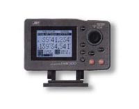
- Approved by the Russian Maritime Register of Shipping
- Large LCD display to provide may graphic modes (CDI mode, Plot mode, etc)
- 12-channel GPS/DGPS receiver
- Up to 20 routes and 499 waypoints are easily stored
- Alarms: Waypoints Arrival, Cross Track Error, or Anchor Watch by selected distance, no fix
- NMEA-0183 output
- Multi-language: English, Germany, Norwegian, French, Spanish, Italy and Japanese
Specification:
| Display: | STN LCD 128 x 100 dots |
| Display Size: | 79 Ч 61 mm |
| Weight: | 0.9 kg |
| Frequency: | 1575.42MHz ± 1MHz (C/A code) |
| Sensitivity: | -130dBm for acquisition,
-133dBm for track
|
| Position update: | every 1 second |
| Waypoint Memory: | 499 with up to 8 character alphanumeric designation |
| Route Plan: | 20 plans |
| Position Correction: | By Geodetic datum or manual L/L entry |
| Alarms: | Waypoints Arrival, Cross Track Error, or Anchor Watch by selected distance, no fix |
| Magnetic Variation: | Automatic with year table and Manual |
| Selectable Units: | NM/KT, SM/MPH, KM/KPH |
| Plot function: | 1/8 nm to 100 nm |
| Data Output: | Single NMEA 0183 |
| Data input: | From other equipments in NMEA |
| Memory Backup: | Lithium battery |
| Dimensions: | 104 x 126 mm |
| Weight: | 1.2 kg |
| Power Requirements: | 10.8-16 VDC |
| Power consumption: | less than 6W (with GPS/DGPS receiver) |
| Operating temperature: | -25°C to 70°C |
| Storage Temperature: | -40°C to +85°C |
| Humidity: | +40°C, 40% |
Components:
1.Antenna GPS112 (15 m cable, instruction manual)2.GPS/DGPS display J-NAV500 (power cable, fuse, instruction manual)3.RMRS Sertificate
 JLR-7500, JLR-7800 (D)GPS navigator
- 5.7?inch high visibility display
- Great Circle and Rhumb line in the same route
- Various display modes available
- Advanced port configuration
- LAN for route data transfer and interswitching
One of the new display modes is the 3D highway, which allows you to intuitively view the location of the next waypoint. This 3D guidance is particularly valuable to follow a real-time chain of waypoints along a planned route.
The new (D)GPS navigator allows you to plan long distance routes highly effective. It is possible to set Rhumb lines (RL) for short legs, while Great Circle (GC) can be set for the long distance legs – all possible within the same route. Simply make your selection for each leg to reach your destination effortlessly.
The newly developed sensors includes RAIM, which is to access the integrity of GPS signals. If multiple satellite signals are picked up, this system will check if the position fix is consistent with the computed position, assuring higher reliability than conventional methods.
The (D)GPS navigator integrates four configurable NMEA ports. This advanced feature will allow you to e.g. have one port configured with the latest NMEA standard, while another port is capable of running a previous version. In this way you can connect older equipment onboard. It also has one in and two contact outputs and LAN, which facilitates route data transfer and/or interswitching.
Via a LAN connection, you can easily connect two displays. The second display is fully operable and auto synchronises with the main display, which is directly connected to (D)GPS sensor, allowing
e.g. acknowledging alarm or adjusting waypoints/routes at a secondary location on the ship. You can also set for a dual installation, having two (D)GPS sensors connected to two different displays to simply switch when necessary, assuring you always on.
Standard supply:
- Display NWZ-4740 including bracket
- GPS sensor JLR-4340 for JLR-7500 or DGPS sensor JLR-4341 for JLR-7800
- Cables (Power cable display 2 m, Sensor to display 10 m (JLR-7500) / 15 m (JLR-7800), Display to junction box 5m)
- Installation & Spare parts
- Operation guide/manual
- Installation manual
Optional items:
- Rectifier NBG-320
- Printer (table mount) DPU-414
- Connection box CQD-10
- Data switching unit NCZ-777
- Junction box NQE-7700A
- Extension cable (15 m) CFQ-9000
Specification:
| Display: | 5.7-inch, white LED backlit, 320 × 240 pixels |
| Dimmer: | 4 stages (bright, middle, dark, off) |
| Power supply: | 10.8V to 31.2V DC, <10W |
| Contact signal output:: | 2 ch |
| Contact signal output:: | 1 ch |
| LAN: | built-in 10/100 Mpbs |
| Data backup: display: sensor: |
flash ROM SRAM with battery |
| Waypoint input: | LAT/LON, bearing/range, event, TD |
| WPT/route data transfer: | via LAN and RS-232C |
| Track/route: | 2000 points, 100 routes with 512 WPT per route |
| Plot scale: | 0.2, 0.5, 1.2, 5, 10, 20, 50, 100, 200, 300 NM |
| Plot interval: | 1 up to 60 min (1 sec) or 0.01 to 99.99 NM (0.01 NM) |
| Navigation calculation: | select Great Circle and Rhumb line for each leg (total distance up to 99,999 nm) |
| Screen mode: | LAT/LON, CDI (highway), trackplot, GPS sat. info, enter WPT/route planning, WPT info |
| Alarms: | arrival, anchor, boundary, off-course, no position fix, speed, trip, temperature (Via external temp sensor), depth (Via external echo sounder), HDOP |
| Adjust magnetic variation: | Auto / manual |
| Geodetic system: | 46 systems |
| LORAN C/A convert: | convert LAT/LON to TD of LORAN C/A |
| GPS specs: | |
| Receiver/sensor type: JLR-7500 JLR-7500 |
multichannel (12 ch), SBAS (1 ch) multichannel (12 ch), SBAS (1 ch), DGPS integrated |
| Frequency: | Frequency1575.42 MHz ±1 MHz (C/A code) |
| Satellite tracking: | up to 12 satellites |
| SBAS: | WAAS, MSAS, EGNOS |
| Accuracy: HDOP <4 SA off SBAS beacon |
13 m 7 m 5 m (JLR-7800 only) |
| Power supply: JLR-7500 JLR-7500 |
10.8V to 31.2V DC, <1.5 W 10.8V to 31.2V DC, <2.5 W |
| NMEA: | ver. 1.5, 2.1, 2.3 |
| Bit rate: | 4800, 9600, 19200, 38400 |
| Output: | GGA, RMC, GLL, VTG, GSA, GSV, DTM, GBS, GRS, GST, ZDA, GNS, MSS (Only JLR-7800), ALR, VDR (Via external speed log), VHW (Via external current meter), APB, BOD, BWC, BWR, RMB, XTE, ZTG, AAM, ALR, RTE, WPL, ACK |
| Input: | HDT, THS, BDT, DPT, MTW, CUR, VBW, VHW, ACK, WPL, RTE ALR |
| Interval: | 1, 2, 3, 4, 5, 6, 7, 8, 9 sec and off |
| Operating temperature: sensor display |
-25° to 55°C -15° to 55°C |
| Storage temperature: sensor display |
-40° to 70°C -25° to 70°C |
| Operating humidity: | 0% to 93% non-condensing |
| Water resistance: sensor display |
IEC60945 (ed.4), USCG CFR-46 IP44 |
| Dimensions: Display NWZ-4740 Sensor JLR-4340 (JLR-7500) Sensor JLR-4341 (JLR-7800) Rectifier NBG-320 |
142 × 93 × 239 mm Ø108 × 108 mm Ø 134 × 155 mm 135 × 165 × 140 mm |
| Weight: Display NWZ-4740 Sensor JLR-4340 (JLR-7500) Sensor JLR-4341 (JLR-7800) Rectifier NBG-320 |
2.3 kg 0.7 kg 1.7 kg 3.3 kg |
JMC GP-200
- Low cost GPS Navigator housed in compact cabinet for small vessels
- Built-in 18-channel WAAS/DGPS-ready GPS receiver
- 4.5-inch high-contrast monochrome LCD with longlife white LED backlighting
- Stores 2000 waypoints, 20 routes with 100 waypoints each.
- Track plotting page with 1000-point trackline history and 10 scale ranges
- Devoted MOB key for instant and protected storage of current position
- Offers user-definable 1/2- or 1/4-split display page for customized operation.
Specification:
| Display: | 4,5″ LCD |
| GPS receiver: | 18-channel parallel, 1575.42 MHz |
| Corrections: | WAAS / DGPS |
| Renewal rate: | 1 sec |
| Accuracy: | 10 m (w/out correction)
5 m (DGPS) 3 m (WAAS)
|
| Memory: | 1000 user points |
| Routes: | 20, each with up to 100 waypoints |
| Alarms: | arrival, anchor, cross-track error, DGPS, time, low battery |
| Power supply: | 11 – 40 VDC, 3 W |
| Interface: | NMEA-0183 and RTCM-104 |
| Operating temperature: | -15°C to +50°C (receiver)
-25°C to +70°C (antenna)
|
| Dimensions: | 215 × 80 × 130 mm |
| Weight: | 650 g |
JMC NP-20NT GPS Track Plotter
- The display unit consists of a 7-inch panoramic daylightviewing TFT LCD screen housed in a splash-proof case mounted on a quick disconnect bracket pedestal for safe storage when not in use. Screen backlighting and contrast levels are fully adjustable.
- Advanced hardware based on a 200 MHz high-speed ARM series CPU draws C-MAP’s NT/NT+ electronic charts four times faster than previous C-MAP series of JMC plotters.
- A new 12-channel GPS receiver is supplied as standard. A 3-channel I/O interface also allows an additional NMEA-0183 GPS data source or a C-COM modem to be connected.
- Object-oriented cartography displays all available information in a pop-up window as soon as the user points to a map object icon of interest, such as a port, an obstruction, a wreck, a buoy, a lighthouse, a tidal station or a user point. Information on user-specified coordinates anywhere on an NT/NT+ chart can also be found through a couple of keystrokes.
- The coordinate system supports UTM and currently active worldwide Loran-C TDs as well as the conventional LAT/LON coordinates to 1/1,000 minute, *1/10,000 minute, or to 1/100 seconds. * Storage to 1/1,000 minute.
- The map can be oriented for head-up or course-up presentation with the resolution angle adjustable in 1-degree steps.
- A single keypress activates the home mode, showing the current position fix at the map center at all times, while scrolling the map automatically.
- A devoted, separately placed Man-Overboard (MOB) key stores your present position as the MOB waypoint in the event of an accident, and automatically guides you to that point by showing its bearing, distance and estimated time of arrival.
- Advanced user-interface allows single-touch on-screen entry of a desired destination and automatic startup of navigation to that point.
- An infrared remote control unit is supplied as standard, giving you full access to all plotter functions, including power on/off, without having to touch any key on the display unit.
Specification:
| Display: | 7.0″ panoramic, backlit TFT LCD (480 × 240 pixels), daylight-viewing, housed in splash-proof case |
| GPS Receiver (Model GP-280): | 12-channel parallel, 1575.42 MHz, C/A code |
| Display Modes: | Map & Nav. Data, Full Map, Map & Depth, Navigation, 3D-Runway (moving highway), Satellite Information |
| Map Orientation Modes: | North-Up, Head-Up, Course-Up |
| Coordinate Systems: | LAT/LON to 1/1000 or 1/10000 min., UTM and Loran-C TDs |
| Cartographic Cards Supported: | C-MAP NT & NT+ |
| Card Slot: | 1 |
| Tracklines: | 5 selectable |
| Track History: | 2,000 GPS fix points/trackline (10,000 in total) |
| Track Colors: | 7 selectable |
| Track Storage Intervals: | 1/5/10/30 sec/1/5/10 min. or 0.01/0.05/0.1/2/5/10 nm |
| Routes: | 20, each with up to 100 waypoints, reversible |
| Built-in User Point Storage: | 1,000 points (waypoints, marks & events combined) |
| User Point Options: | 16 symbols and 7 colors selectable for each point, each with user-defined alphanumeric name tag |
| MOB Waypoint: | 1 |
| Alarms: | Arrival, Cross-Track Error, Depth, Anchor, Grounding, HDOP |
| Optional User Data Cards: | 1 MB, 2 MB & 4 MB |
| I/O Ports: | 3 (NMEA-0183 or C-COM) with 1 port allocated to GP-280 GPS receiver |
| Power Requirements: | 10 to 35 VDC, approx. 7.5W max. |
| Display Unit Weight: | Approx. 1.1 kg with mounting bracket-pedestal attached |
| Display Unit Dimensions: | 241 × 203.5 × 112 mm with mounting bracket attached |
JMC RD-300 Remote Display
- 4.5-inch high contrast LCD housed in compact electrostatically shielded cabinet for ease of installation in space-limited area;
- Single interface cable connection to host NMEA-0183 equipment. 10m standard. Longer cable optionally available;
- Displays standard NMEA-0183-formatted data including LAT/LON position, bearing, speed, distance traveled (odometer), depth, water temperature, and time (UTC or local, 12-hour/24-hour format).;
- Up to four data types can be selected for display at a time.;
- Audible and visual alarms for preset depth, temperature and speed readouts;
- Interfaceable with JMC and OEM brand GPS track plotters, fish finders, and navigation sounders.
Specification:
| Display: | 4.5-inch high contrast monochrome LCD |
| Data Displayed: | position (LAT/LON), bearing, speed, odometer, temperature, time (UTC/LST, 12H/24H) |
| Alarms: | depth, temperature and speed, audible and visual |
| Power Requirements: | 11-40 VDC, floating ground, approx. 3W |
| Interface: | NMEA-0183 Version 2.0 & up/IEC 1162 |
| Interface Cable: | 10 meters (standard), longer cable (option) |
| Ambient Temperature: | -15 to 50°C |
| Max. Dimensions: | 215/175 × 80 × 130/108 mm with/without mounting bracket |
| Weight: | approx. 650g with mounting bracket |
Samyung SPR-1400
- Compliant with IMO and RMRS standards
- Small size, Light weight, Easy installation
- All data can be displayed in one sereen with big letters
- Interface with PC to print out destination, marks and routes
- No need to initial set-up, fully automated
- Easy night navigation with full light support in screen at every stage
- Temporary plotter function
- WGS-84 compartible
Specification:
| Type of receiver: | digital 12channels multi tracking type |
| Receiver Frequency: | L1 1575.42MHz(C/A CODE) |
| Sensitivity: | below -130dBm |
| Accuracy:
GPS position: DGPS position: DGPS speed:
|
10m 2D RMS
3m 2D RMS 0.1Knot 2D RMS
|
| Display: | 3″ LCD, 128 × 64 dot |
| Destination Memory: | 1000 points in total |
| Display Modes: | Temporary plotter, Steering, Highway, Navigation Data, User mode (Digital Speedometer) |
| Plotter Mode: | 0.02, 0.05, 0.1, 0.2, 0.5, 1, 2.5, 19, 20, 50, 160, 320mm |
| Highway Mode: | 0.2, 0.4, 0.8, 1, 2, 4, 8, 16nm |
| Output: | RS-232C/422 & TTL |
| Input: | RS-232C/422 (RTCM) |
| Power supply: | DC 10-36V / 0.08-0.3A (Max. 4W below) |
| Temperature:
Display: Antenna:
|
-20°C to +55°C
-40°C to +85°C
|
| Dimensions: | 159 × 103 × 67 mm |